Urban

MindMixer – Supporting public dialogues

Mind_Mixer_01
MindMixer is a tool that lets citizens and community planners engage in public dialogues without meeting personally. It was inspired by town-hall-style meetings, where engaged citizens talk to their representatives and expose their views on the decision-making process. Such meetings, however, require the citizens to be at certain place at a certain hour, something that someone with family and work obligations might not be able to achieve. As a result, only a narrow demographic group can attend such meetings regularly and broad sectors of the population can not let their voice be heard.

MindMixer addresses this problem and takes the town-hall discussions online, through a web application that connects local institutions with the citizens. Universities, hospitals, and school districts can open conversations about a certain topic and collect the views of the community members. The system gives the city representatives important information about the decision-making process. For example, they have access in the back-end to demographic data of the people who are posting their views. In one particular case there was strong support for extended library hours, however they found out that most of this support came from the downtown areas. This data can lead, for instance, to extend the opening hours of only those libraries at the downtown.

MindMixer makes easier for governments to involve the citizens in the decision-making processes and take a wider range of opinions into consideration. For the citizens MindMixer offers an uncomplicated way to participate in the public discussion and let their voice be heard.

Watch some videos about MindMixer

Cyclephilly – Citizen generated data

Cyclephilly © cyclephilly.org 
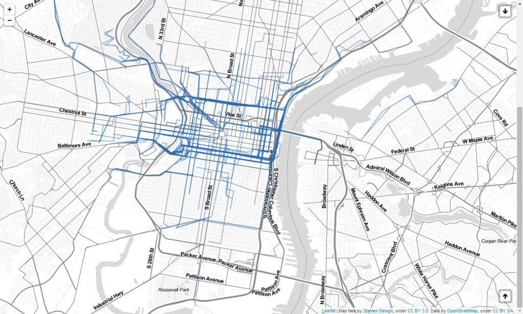
Cyclephilly is an online map and a mobile application that let the users record their daily routes in the city of Philadelphia. Although it has been around only for a couple of months, it can be already called a success story.

A great thing about Cyclephilly is that it was in part developed by a non-programmer, Corey Acri. He came in contact with Code for America with little coding skills but with a good understanding about the institutions and instruments needed to push a project like this. He and his team colleagues, Lloyd Emelle and Kathrin Killebrew, worked together with the Delaware Valley Regional Planning Commission and Bicycle Coalition of Philadelphia to design the app. Since the launch of Cyclephilly in May it has managed to attract about 150 users, which in turn have recorded more than 5000 trips. The numbers speak by themselves.

(more…)

Homebrew sensing project – Citizen science

Homebrew spectrometer © Jeff Warren
In the everyday life we might get in touch with hazardous chemicals even without noticing it. Building materials, fabric dyes, additives in food and contaminants resulting from fracking can expose us to hazardous materials. This can have a serious impact on the health of whole communities. When the effects of chemical exposure and the resulting health problems become evident, the community affected faces a complex and often lengthy process to demonstrate the presence and the impact of such chemicals in their environment.

If a community realizes that its environment is being affected by chemicals it would normally have to collect and send samples to a laboratory. Such process can be quite expensive due to the highly specialized equipment and the expert roles involved in the analysis. However such analyses can be simplified by creating affordable yet reliable tools that enable the citizens to collect and analyze samples of for example water, and test the presence of toxic materials such as mercury.

The homebrew sensing project supports the creation of reliable and open tools that can be used by non-experts. The project focuses specifically on spectrometry, a powerful method to identify materials. To achieve this, the initiators have developed a low-cost spectrometer that allows anyone to carry out spectrometric analyses at home, empowering common people to obtain information about hazardous materials in their environment.

Homebrew sensing project © Jeff Warren Watch a video of the spectrometer…

neighbor.ly – Altruism in the digital age

© neighbor.ly - Fund raising for local communities 
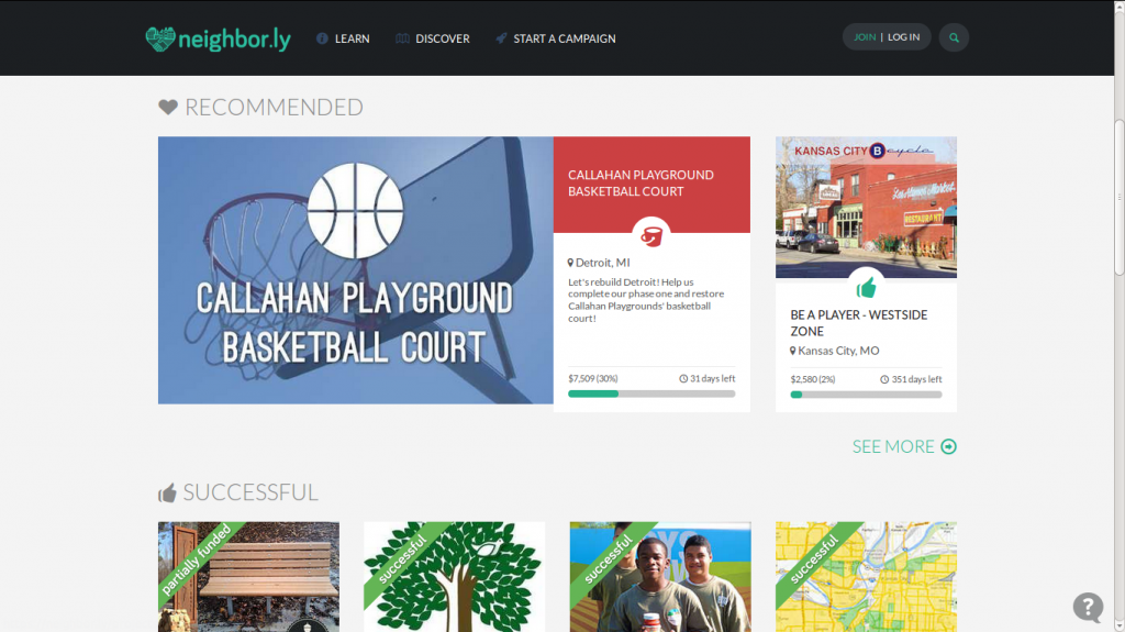
Neighbor.ly is about supporting altruism at a local scale through on-line tools. While it has a similar structure to other donor sites, it focuses on projects that are intended for a specific location and are started by certain organizations. Neighbor.ly privileges quality and close connections with local structures.

Not every person can start a project in neighbor.ly. Only neighborhood groups, governmental entities and some qualified non-profits can submit their ideas and raise funds through neighbor.ly. Individuals should team up with such organizations to submit projects. The restriction assures a minimum level of quality and of support for the projects. This is a distinctive characteristic of neighbor.ly that prioritizes quality over quantity.

© neighbor.ly - Fund raising for local communities (more…)

Fruit city – Mapping fruit trees

Fruit city map &copy, fruitcity.co.uk - Vahakn Matossian 
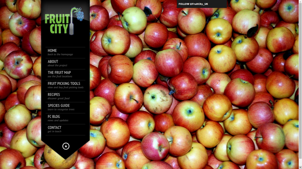
Fruit city is an online application that lets the users map fruit trees in London. The project offers a handful of tools that encourage the collection of fruits within the city. In this way the initiators want to promote the use of available resources, avoid the wasting of edible goods and support an environmentally friendly food system.

A great portion of the fruits sold in cities come from distant places such as Brazil, Chile or South Africa. While this supports the economy of those countries, the transport of goods has a considerable footprint . Growing food locally has gained importance in recent years as a way to create a sustainable food system. The idea of fruit map is to use food sources that are already available in cities and provide helpful information to the citizens on how to do that. (more…)

Stereopublic – The hunt for quiet places

Stereopublic is a both an app and an online map that let the people of some cities geo-tag quiet places in their surroundings. The project is a collaborative effort that encourages the people to navigate their cities and consciously enjoy the sound scape. The goal is to create world-wide database that lets the people find relaxing places in the city.

Our vision plays a predominant role in the way we experience the world and many environments are focused on the visual aspects of things. Stereopublic makes us aware of the sound scape of our cities and how a quiet place can also provide a great pleasure for our senses. In a way, stereopublic creates a new sort of citizen, an audio flâneur, someone who wanders around looking for those places that are not only pleasurable for our eyes but also for our ears.

The stereopublic map of London. Stereopublic - A hunt for quiet places © stereopublic.net 
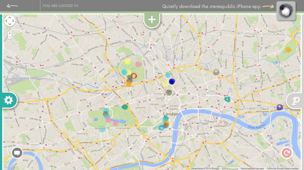
If you want to become part of the hunt for quiet places you can download the stereopublic app for free and start wandering around your city. Once you find a new or your favorite quiet place, you can create a geo-tagged entry for it in the map and give it a color according to your current mood. If you really enjoy that moment you can take a 30 seconds long record and upload it, so that the whole world can have a bit of your quietness.

The length of the recordings require a particular pace, as you need to expend 30 seconds in the place that you want to record. Half a minute can be short for many, but in a busy city it can be a lot of time, so taking part in the project demands also a certain state of mind. Some of the recordings are enhanced with compositions made by Jason Sweeney, the author of the project.

Stereopublic won a City 2.0 TED Prize award and was also supported by the Australian Government through the Australia Council, its arts funding & advisory body, the Government of South Australia through Arts SA, Adelaide City Council.

Stereopublic credits


Video: Jason Sweeney
Devised, directed and composed by Jason Sweeney
Creative Producer: Martin Potter
Interactive Producer: Nick Crowther
Designer: Amy Milhinch
Design Studio: Freerange Future and the team of:
Yuri Tománek, David Walker, Deanna Daminato,
Lisa Iacopetta, Abdul Rauf, Minka Park.
Architectural Consultant: Dale Wright

Leerstandmelder – Mapping of vacant spaces

Leerstandmelder
Leerstandmelder is an online map that allows city inhabitants to report vacant spaces in their surroundings. The map highlights in this way some of the inequalities created in the city by long-term vacant spaces, as such could be inhabited or used by people in need for them. According to a report released by The guardian many of the empty spaces in Europe are bought just as investment and some have never been used.

The phenomenon has already reached an alarming scale, as approximately 11 million houses remain vacant in Europe. It doesn’t matter if they are old or new, living or industrial spaces, if they are in the centre or the periphery, or if they are public or private. They directly affect people who struggle to find affordable flats and work spaces in their cities.

(more…)

Restaurant day

Created in 2011 by Timo Santala, Olli Sirén and Antti Tuomola the Restaurant day encourages common people to open their own restaurants, cafés and bars for a single day. The initial restaurant day was the result of the founders’ frustration with bureaucratic hurdles and regulations that made impossible to create pop-up eateries in Finland. They discovered, however, that the Finnish laws allowed to open a restaurant without permits if was only for a single day. Then they came with the idea of promoting a bit of civil disobedience by organizing the restaurant day, an event that turns the city into a carnival that promotes and celebrates food culture, only for a day.

Pikku-Berliini, Helsinki 17.2.2013 Photo: Tuomas Sarparanta (more…)

Civil Debate Wall – A place for debate

Civil Debate Wall
The Civil Debate Wall allows students, teachers and citizens to share their positions regarding a broad range of national issues such as income distribution, civil rights, and environmental policies, among others. The debates are made possible by a system that by mixes large touch screens with a website and a texting service to connect the opinions and create constructive dialogues across different platforms. The elements of the system are synchronized to deliver a single experience to all the participants and enable the following of a particular discussion.

The Wall is installed at University of Florida’s Pugh Hall. It comprises 5 large touch screens that show the current question, an answer to this question an a picture of the answer’s author. The users can engage by touching the screen and creating an answer to the main question or by giving a reply to another user’s answer. After posting their comment, they can decide whether they want to follow the conversation through text messages.

(more…)

596 Acres


In New York City there are more than five hundreds acres of publicly owned vacant land that are not being used and remain closed behind fences and chains. This land is concentrated in neighborhoods that are in need for beneficial land uses such as community gardens. 596 Acres is a project that facilitates access to New York city’s publicly owned land through the use of open source tools and hands-on mentorships. In this way, 596 acres help the communities to access unused lots, transform them temporarily, and so, improve the quality of life in the area where they live in.

596 in East Harlem © 596 Acres (more…)