Urban

citymaking.wien – Pop Up Parklets!

Citymaking.wien
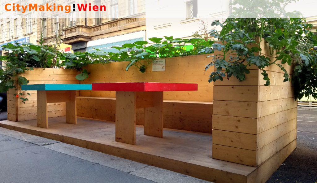
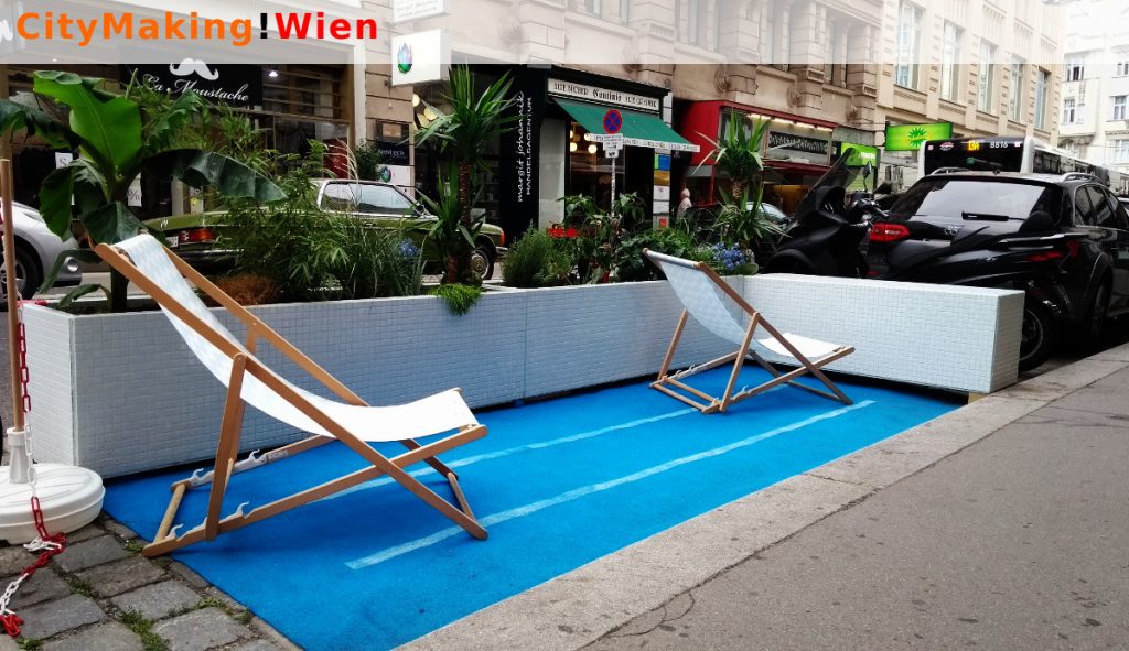
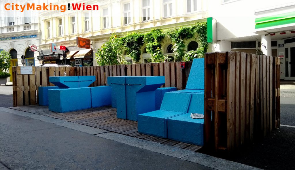
Important information: Please do not forget to answer our survey (6.5 min). Thank you!
CityMaking!Wien is an online toolbox that facilitates the conception, design and submission of parklets in Vienna. With this tool we want to make it as simple as possible for the citizens to participate in the development of their neighborhoods.

At the moment CityMaking!Wien offers four different tools:
  1. Basic information about parklets and what should be considered for the conception and construction of a parklet in Vienna, regarding the security, the design and other aspects.
  2. A parklet potential map that shows where would be possible to build a parklet, by showing in red the different restrictions that apply for the use of parking places. The map simplifies the understanding of the regulations and offers a new understanding about public spaces.
  3. A design tool that facilitates the creation of the required drawings for the submission. The tool is very simple to use, yet it has considered many of the requirements regarding dimensions and security. People can also download the drawings and edit them according to their own visions.
  4. An online submission tool that facilitates the contact with the authorities and the submission of the required documents to obtain a permit for the use of parking places.
With these tools we want to encourage people to become active and submit their ideas using the online form. The final decision regarding the use of parking places is taken by the city of Vienna. The toolbox is a great example on how technology can trigger new dynamics in cities, by providing new understandings of public spaces.

Last but not least CityMaking!Wien is also testing the impact of technology in citizen participation. We want to find out if technology does truly fulfill the promise of making participation and engagement easier, or if web-applications really encourage people to become active in their neighborhoods.

To answer these questions we are running an online survey and we are really thankful for your answers and your time (it takes in average 6.5 minutes). The website is being develop as part of the PhD thesis “New methods of citizen participation based on digital technologies” at the Austrian Institute of technology.

Citymaking.wien Citymaking.wien Credits: Conception and development: Juan Carlos Carvajal Bermúdez, Matthias Herret.
Host organization: Austrian Institute of Technology
Media Partners: mediaarchitecture.org, streetlife.wien.

Call for chapters: Designing Smart for Improving Place

Alessandro Aurigi, Professor of Urban Design at the University of Plymouth, and Nancy Odendaal, Associate Professor in City and Regional Planning at the University of Cape Town, are putting together an edited book publication, titled “Designing Smart for Improving Place”:

This book will challenge scholars, practitioners and thinkers to look at smart from the point of view of the inhabitable, and inhabited, culturally-informed, digitally-enhanced place. We propose a contextually grounded approach that examines the notion of the ongoing (co)production of the localized smart city: innovative, emergent and situated initiatives that substantively connect to the specifics of place. As such, the book aims at the difficult but necessary target of allowing a joined-up approach on smart, with the permanent improvement of place in mind. This means informing the present and future shaping of smart place by architects, designers and urban planners.

Extended abstracts are due Friday 27 October 2017. More details are available on their book website.

Blitzfänger for “Human Futures” @ Aspern Seestadt


BLITZFÄNGER is an interactive installation that allows up to 9 people to create and control lightning on a large-scale LED screen. As a homage to the power of nature and our attempt to control it, the audience is invited to grab one of the 3 meter poles from the floor and position them vertically like lightning rods. As soon as they do a system detects their position and lightnings appear on the LED screen allowing them to control them with their movement.

This project was created as part of the ‘Human Futures’ program of artistic exchange between Europe and Canada and under the ‘living spaces’ curatorial theme. BLITZFÄNGER took place at the entrance of a new residential complex outside of Vienna in between the train and the buildings and was designed to disrupt the routine of the inhabitants that just go in and out of the complex allowing them to get to know, or at least see the people they live around.

Created by Iregular
Concept, graphic and sound design: Daniel Iregui
Technical Direction: François Loubert-Hudon
Technical Assistance: Juan Carvajal
Produced by: Media Architecture Institute
Powered by: X-Agora
Curated by: Gernot Tscherteu

funded by the European Union
EU_flag_cult_EN

Urbancult – Mapping urban art in Indonesia

Urbancult - Street art in Indonesia © urbancult.net 
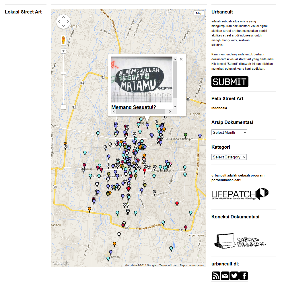
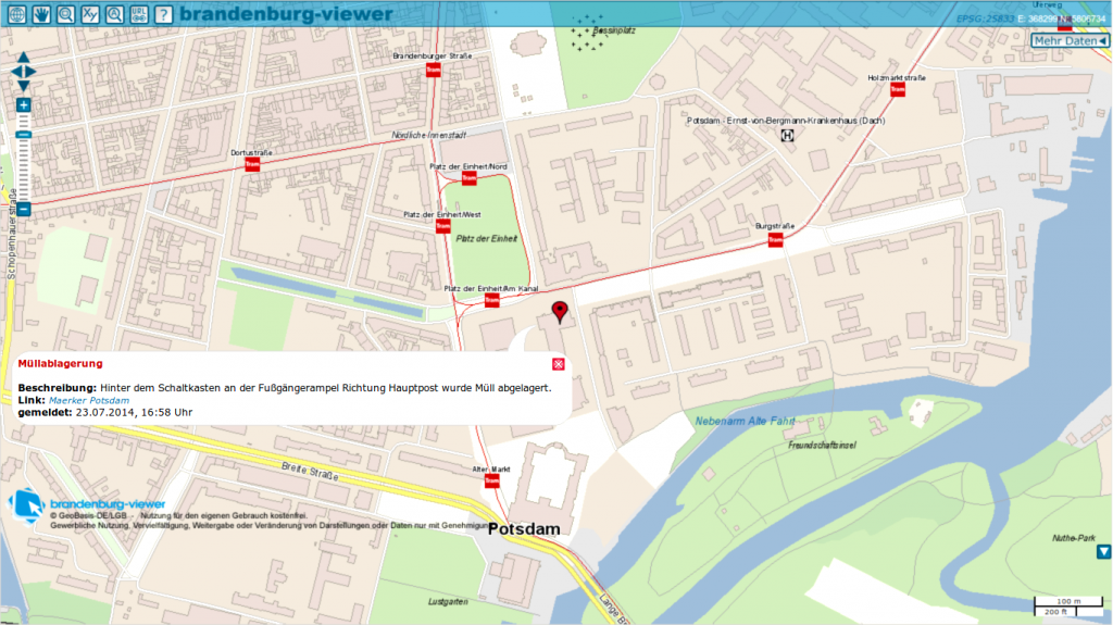
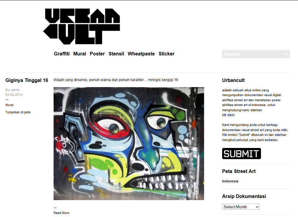
Urbancult is a visual documentation and archiving project that shows the location of street-art works in Indonesia. The goal of urbancult.net is to create a map with the location and pictures of street-art works. Through the map they can keep the public informed about new street-art works, strengthen the community, and show how the murals evolve with the time.

Urbancult - Street art in Indonesia © urbancult.net

Beginnings


The initial thriving force behind Urbancult was Agung Geger and his passion for taking and collecting pictures of murals in Yogyakarta. The project started quite informally in 2011, after he met with Andreas Siagian and got some advice from him on how to upload his pictures and make them more accessible for fans and other street-art artists. This gave origin to “A tribute to street-art murals of Jogja”, i.e. a compilation of street art photographs on the personal Facebook account of Geger. Through his Facebook album Geger enterd in contact with artists, as well as with the community interested in the street art of Yogyakarta.

Later in 2011, Ucok suggested that the compilation should be published on their own web-site. This would make the compilation accessible to a wider audience, as the Facebook site was restricted to personal contacts. Geger joined forces with Ucok to publish all the street-art pictures piled up in their database. They began creating an online documentation and a map with the location of street-art works in Indonedia.

In January 2013 Budi Prakosa (Iyok) joined the team, bringing his experience as creative web programmer in DeadMediaFM, a community develop podcast and online radio streaming of Indonesia. With the help of Iyok the team extended the urbancult’s interface to display the location of the murals stored in the database. Finally the Urbancult was officially launched in February 2013, with the support of Agus Tri Budiarto and Adhari Donora. Later urbancult.net joined Lifepatch – a citizen initiative for art, science and technology, and it remains until now a lifepatch driven project. You can visit the project at urbancult.net.

Urbancult - Street art in Indonesia © urbancult.net

Urbancult’s Credits

Screenshots & pictures: Urbancult.net

FixMyStreet

Fix_My_Street_01 
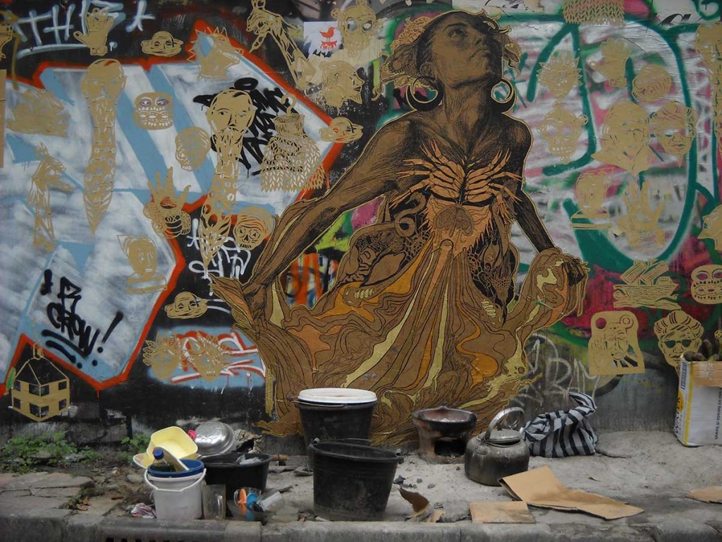
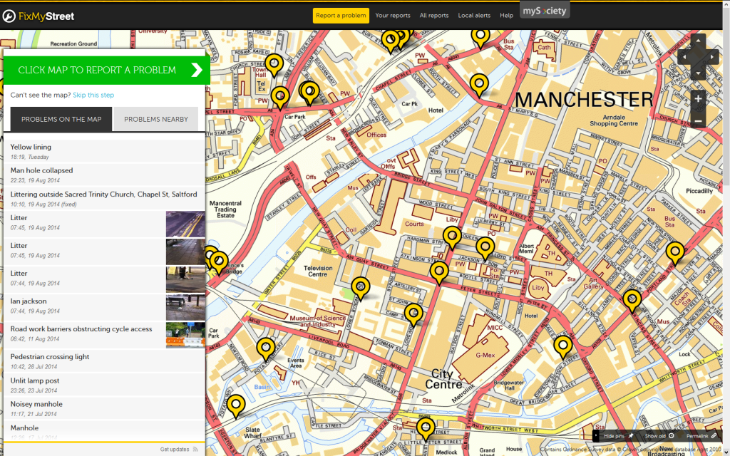
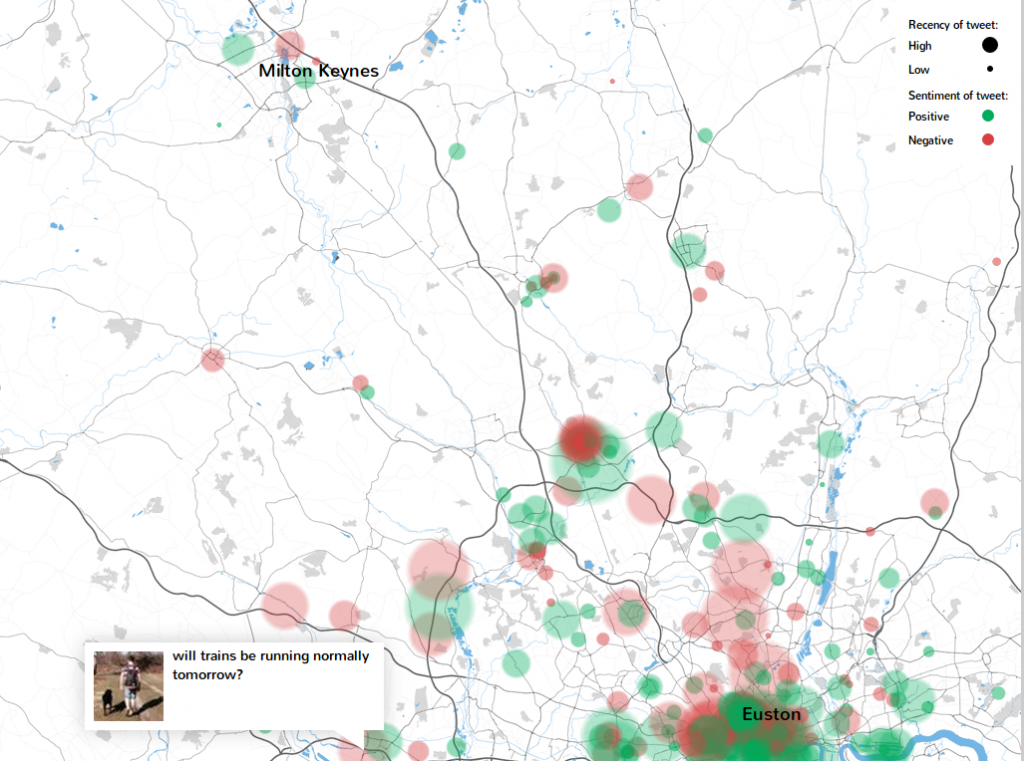
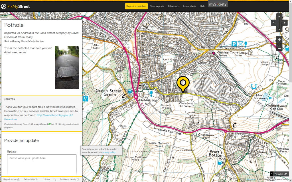
FixMyStreet is a pioneer project of the civic tech area. It is basically a web-application that lets citizens report problems with infrastructure in their city. The reports are then sent automatically to the responsible authorities, who should evaluate and eventually solve them. Potholes in the roads, broken street lights, abandoned vehicles can be easily marked in an online map, the web-app takes care of sending it to the local administration.

Unlike a project like Maerker, FixMyStreet was not started by local governments but by a non-profit organization called mySociety. Thus, the website does not take responsibility for resolving the problems reported, it just creates an easy way for the citizens to take action when they see some defect in the city’s infrastructure. This information is then forwarded to the corresponding authorities, who can process the requests and address the issues reported. The system should also prevent the repeated report of a single problem, streamlining the maintenance of infrastructures in the city. The application is now offered as a service to city councils.

As most of the web-based applications, FixMyStreet works across different platforms: desktop and mobile devices are supported and it can be accessed through the browser or through their own app. Since its launch back in 2007 the project has inspired other projects in other cities in all corners of the world. Similar applications have been created in Australia, Canada, Korea, New Zealand, Japan among others. As the code of the application is open source, other cities have continued its development, adding new features and adapting it to the particularities of each administration. For example, the Norwegian Unix User Group (NUUG) implemented FiksGataMi, adding support for openstreetmaps, and making many improvements to the code.

Fix My Street - Civic technology to report infrastructure problems
Credits:
Screenshots: FixMyStreet

Motor city mapping – Rescuing Detroit from urban decay

The aim of the Motor City Mapping project is to support the renaissance or the creation of strong neighborhoods. Many buildings and homes in Detroit have good structural conditions, often with remarkable architecture and beautiful features, yet they are abandoned because of the blight that surrounds them. When the inhabitants realize that there is no future for their neighborhood’s they are simply forced to move somewhere else.

To counteract this trend, it is crucial to accelerate the process of demolishing the vacant buildings in poor conditions. However, identifying such buildings is an enormous task, that requires man force, inventiveness and a bit of technology. The Blight Removal Task Force was created to provide the City of Detroit with a blight removal system that use all the existing resources in Detroit and suggests new recommendations to set up a scalable, efficient, and environmentally safe strategy. As part of this strategy the Task force teamed up with Data Driven Detroit and Loveland Technologies to create a system to report, store and process the data related to structures in poor conditions.

Motor city mapping project © https://www.motorcitymapping.org (more…)

Sentiment mapping – Feelings about transport infrastructures

Sentiment mapping, feelings about public transport. © commonroute.commonplace.is Commonplace is developing a web-based sentiment mapping application that monitors social networks to identify the citizen’s feelings in regard to public transport, road traffic, commuting nodes and other transport infrastructures. It is being developed in collaboration with the Royal College of Art, a leader in the application of design led thinking.

The goals of the project are ambitious. The idea is to combine information of different sources, like weather stations, social media, and official reports to help the passengers plan their journeys in an efficient and stress-free way.

The project is still in a very early phase of development. However, a simple prototype that fetches, stores and displays tweets concerning multiple transport modes is already available. The current version shows an area between London and Milton Keynes, where the passenger’s sentiments are shown in red and green blobs. Another graphic shows the evolution of the mood during the day, including those about trains, buses and tubes.

(more…)

Maerker – Fix my -german- street.

Maerker_brandenburg_02 Maerker is a web-based application that lets the citizens of Brandenburg report issues with the infrastructure of their municipality. The project is already available for about 60 communities in Brandenburg, including Postdam, the state capital. Recently the project has been also implemented in Berlin, where three out of its twelve boroughs offer Maerker services as well.

It is a simple system that lets the citizens participate actively in the administration of their municipality. Maerker forces the bureaucracy to react in an open way to the request of the citizens. The answers to the issues submitted fosters better coordination between institutions, giving to the actual concerns of the population the highest priority.

There is a wide variety of problems that can be reported. From illegally disposed waste through to road damages or failures in traffic lights. The local administrations provide feedback about the report’s current status. With a traffic-light like system it is possible to identify the current status of an issue. Red means that the issue is pending to be reviewed, yellow shows that the problem has been identified and is in process of being solved. Green represents a problem fixed. (more…)

We are on a boat – Onboard sharing

We are on a boat is a mobile app that lets people who own a boat share it with people who would like to be on board. As simple as that.

Everyday, awesome people willing to share their journey with others can use the app to offer their board. In exchange they can receive rewards, i.e. goods like food, drinks or some contribution to pay for the fuel. Both passengers and captains can suggest some sort of rewards that they would like to give or receive. To get started captains just need to publish some pictures of their sweet boats and wait for the requests to come.

The passengers can make reviews of their experience and rate the captains. The authors encourage the participants to be respectful with each other and keep a nice and constructive environment among the members.

We are on a boat was initially launched in Amsterdam but the authors hope that it will eventually spread to other cities with a large amount of channels.

We are on a boat © littlenicethings We are on a boat © littlenicethings We are on a boat © littlenicethings Credits:
Video: We are on a boat / littlenicethings
Pictures: We are on a boat / littlenicethings